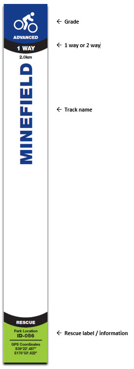
WAYFINDER & SAFETY

CELLPHONE COVERAGE LOCATION

The park has a number of cellphone black spots.  We have placed around the park markers which show where the best cell phone coverage locations are. There is also directional signage scattered throughout the park in the dead spots pointing to the direction of the nearest coverage area.   We recommend you look out for our signage and make yourself familiar with them.

TRAIL MARKERS

Mountain biking is a sport with a reasonable element of risk and accidents will happen. 

We know that when an accident happens people don’t always think clearly so we have gone to some effort to ensure if you have a bad accident, you can be reached quickly. 

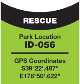
In case use need emergency assistance all our trail markers have an identifying number and GPS coordinates on them.  

Ambulances have been instructed to go to the Pan Pac security office to gain access to the park. They have a map that shows the tracks with their identifying numbers. The GPS coordinates are in case you need a helicopter evacuation. 

The best thing to do is take a photo of the nearest trail markers rescue label and then look for cell phone coverage, there are signs in the park showing where the best coverage is. 


In an Emergency – If you have an accident that requires an ambulance, then please follow the following procedure:

  • Ring 111 – ask for Hawkes Bay Ambulance (NB: You might have to move to higher ground to get reception).
  • Depending on the injury, if the rider can get themselves out to the carpark to meet the ambo do so. For a serious injury  when the rider can't geet out themselves ask for a helicopter - access is difficult for an ambulance, and St John don't hold gate keys
  • Give Rescue ID # on nearest track sign to where the injured rider is located (call centre to pass this onto ambo driver/rescue chopper).
  • Ambulance call centre will decide on whether to send an ambulance or chopper, depending on the injury.
  • Wait for their arrival at that location.
  • Pan Pac Security ph 06 831 0100   may be able to assist getting an ambulance in if required.
  • PS: The Rescue ID # on each track sign (and map below), references a pre-loaded GPS location.

RESCUE LABELS: You will find a rescue ID label on all track signs and map boards, each with a unique ID# and a GPS point. These ID# are marked on a trail map that should be in every Ambulance in the district & the rescue chopper – meaning you only need to give the ID# to locate where an injured rider is. Note – mobile reception is a bit non-existent in the lower/valley areas of the forest.